System conceptual model
System conceptual model
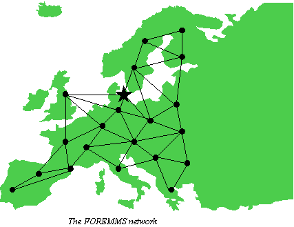
The figure below illustrates a possible network of FOREMMS nodes. Each node represents 1) an intensive data collection site for field and airborne measurements, and 2) an administrative unit with an instance of the FOREMMS system. A node also includes an associated monitoring area, which includes the intensive data collection site. One or more areas covered by high-resolution satellite images and a total associated area covered by medium-resolution satellite images. All the sub-total monitoring regions together cover the whole Europe. Special nodes could be established, like the EEA node proposed in the figure. This node is only for retrieval of information from all the other nodes in the network to obtain a European-level overview of Europe in total.
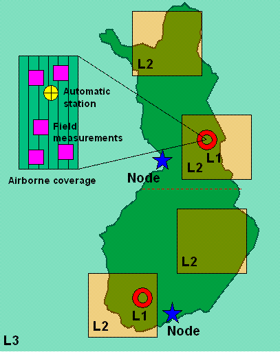
The figure below illustrates in a schematic way the three levels of monitoring. There are two intensive data collection sites (L-1 for Level 1). The two sites are enclosed by associated high-resolution satellite scenes (L-2), which are covered regularly. Additionally, there are two scenes of random location. The sub-total monitoring area (L-3, e.g., represented by the borders of a country) is covered by medium-resolution satellite images.
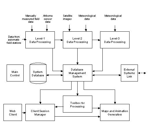
The next figure shows the overall conceptual model. The central module is the Database Management System for storage and handling of the forest environmental data for the specific total monitoring region at hand. Data are processed and delivered from three sub-systems covering different scales and sizes of monitoring areas. The Level-1 Data Processing sub-system receives data from automatic field monitoring stations (e.g., air pollution data), manual field measurements via a special field workstation with GPS, and airborne remote sensing as input. Standardised forest environmental parameters are extracted from these data sources and stored in the system database. The Level-2 Data Processing sub-system extracts the same parameters on medium scale from satellite imagery using Level-1 data from the local node areas for calibration of the classification methods and inversion models. The Level-3 Data Processing sub-system does correspondingly at large scale covering the whole monitoring region and using Level-2 data for calibration. Time series of data are analysed by the Toolbox for processing module in order to, e.g., determine trends in the temporal data sets. The presentation of the environmental forest parameters is the done by the module Maps and Animation Generators which makes it possible to study one or more parameters at the same time in 2-3 spatial dimensions and in the time dimension. The module also produces standardised and tailored maps and, also statistical report products for the environmental parameters.
Preliminary functionality
Main Control module:
- Provides main user interface for starting other modules
- Provides functions for customising the system
Level-1 Data Processing sub-system:
- Continuous data measurements from automatic measurement stations transferred by wire or radio links. Measures weather, air and soil parameters
- Man-made measurements during field campaigns. Data are entered in-situ into a portable FOREMMS workstation including GPS recording
- Process airborne imaging spectrometer, ranging radar and/or lidar scanner data:
- Preprocessing (radiometric and geometric correction)
- Classification and/or inversion modelling
Level-2 Data Processing:
- Coverage with high-resolution satellite image data of:
- Fixed areas including Level-1 node areas
- Sampled position images (location varies from one coverage to next)
- Radiometrical and geometrical correction of image data
- Retrieval of forest environmental parameters by classification and inversion modelling
- Applying ancillary data: Meteorological data, field measurements, previous mapping, etc.
Level-3 Data Processing:
- Total monitoring area coverage based on:
- Medium resolution satellite imagery covering total region (preprocessed)
- Level-2 data giving exact parameters for areas covered (gives calibration values)
- Level-3 data from previous coverage time
- Meteorological data from previous until current Level-3 coverage
- Method: Spatial statistical multi-level model
Database Management System:
- Store environmental forest parameters from Level 1-3 (multi-spatial resolution)
- Effective handling of 4-D data sets (spatial + time dimensions)
- Contribution to a standard for exchange of forest environmental data
Statistical Data Analysis:
- Trend analysis in data time series
- Scenario analysis based on trends and possible trends
Advanced Interactive Visualisation:
- Visualisation of single parameters or multiple parameters simultaneously
- Visualisation of data in 2, 3 or 4 dimensions
- Smooth movement of observation point in data space
- Smooth change of data scale
Maps and Statistical Reporting:
- Generation of standard map products for single and multiple parameters
- Generation of map products based on interactively defined presentation in Advanced Interactive Visualisation module
- Generation of standard statistical reports for single and multiple parameters
- Generation of tailored statistical reports for single and multiple parameters
- Generation of web page products for direct public dissemination
External Systems Link:
- Link to other systems (nodes) in the FOREMMS network