Demonstrations and workshop
Demonstrations and workshop
Spanish demostration
The Spanish demonstration took place in the Mediterranean coastal area and covered 200 kilometres of coast, from the Ebro delta to the city of Valencia, and all the sea to the Balearic Islands. Approximate centre coordinates for the demonstration site were 40º N and 0º E.
Located in the centre of the Spanish Mediterranean coast, the Valenciana region (Co-munidad Valenciana) has different environmentally sensitive areas: The natural reserves of the Columbretes Islands (which holds some unique species in the world) and of El Prat de Cabanes, the lagoon (Albufera) of Valencia, the Mata-Torrevieja lakes and many others. The tourist influence of this zone of Spain, which is worldwide known, makes the region of Valenciana very important for the economy. Both the tourist and the fishing industries are at the same time important economic factors and very sensitive to oil pollution.
There are three major ports in the demonstrator area. About 13 million of tons of liquids (e.g. crude oil) and solids (sands, sulphurs, etc.) are transported to and from the port of Castellón. The ports of Tarragona and Valencia have four times the traffic of Castellón. These ports, in addition to an oil refinery and other potential contaminant factories, imply a high risk of oil pollution.
The ENVISYS control centre was situated in the office of INDI (ENVISYS partner) and was operated by INDI's development team.
The cartographic data were provided by the National Cartographic Institute of Spain, and the wind and current data by the Public Company of State Ports (Puertos del Estado).
Many other institutions were involved in the demonstration. First of all, SASEMAR (Rescue and Maritime security in the sea), which is part of the Directorate General of Marine Merchant (Ministry of public works), is responsible for cleanup operations in all Spanish territorial waters. Furthermore, at a regional level, the Directorate General for sustainable development of the Valenciana region, the Environment Department of the Valenciana administration (Environmental Conselleria of the Comunidad Valenciana) and the Emergency centre of La Eliana (the two latter are involved in forest fires and floods). Finally at a provincial level: provincial harbour authorities, other administra-tions (Diputació of Castellón, Government Delegations), Coaster City Halls and the Fisher's Guild
Greek demostration
The test site in Greece was the Cycladic Region of the South Aegean (Notio Aigaio) Sea. Approximate centre coordinates of the site were 37° N and 25° E and the total area was about 25,000 km2.
The Cycladic region includes numerous islands with beautiful beaches, small fishing villages and small communities, with historical background with for example monuments (churches, monasteries, etc.), preserved and protected areas, etc. This type of geographical structure, even though it is considered one of very few in the world, contains many similarities with other areas in the Mediterranean basin, e.g., the southern part of Italy, the Ionian and Adriatica seas, certain areas in Spain, and northern parts of Africa.
The traffic is very heavy in the whole region, especially in the tourist season, which starts approximately in May and ends in October, primarily with passenger ships. There is also a big number of cargo ships (bulk, tankers, etc.) all year long, either local (meaning that origin and destination are Greek ports) or passing by like the famous traffic route of the tankers coming out from Bosporous with destination either a port in a Mediterranean country, Suez or Gibraltar.
INTELLSERVE (co-ordinating ENVISYS con-tractor for Greece) provided both the ENVISYS control centre and its operators.
The University of Athens, Department of Informatics, supported ENVISYS by giving access to its high-speed net-work connection. Sea current data to the demonstrator were provided by the Institute of Physics in Athens (IMPAE) with the collaboration of the National Marine Institute (EKTHE). Wind data were provided by the National Observatory of Athens (NOA), and maps of the Greek islands by EPSILON SA (ENVISYS partner).
Furthermore, ANETKY (ENVISYS partner) co-ordinated the follow-up activities of the demonstration (regional agencies and coast guard activation).
In general, the following users were involved in the Greek Demonstration:
Regional authorities: The Prefecture of Cyclades - ANETKY, located at Syros Island (capital of the Cycladic region) and Port Authorities
Regional level emergencies: PSEA (the responsible or-ganisations under the regional structure)
National level emergencies: the Ministry of Merchant Marine (Coast Guard), the Ministry of Environment and Public Works and the Ministry of Aegean
Financial/economic sector: tourist associations, fishing and sea farming associations and other service providers.
Workshop
March 22.
José Antonio Merchan, INDI, wished the participants welcome to the workshop and gave a brief introduction to the ENVISYS Project.
José Luis Jimeno , mayor of Castellon, expressed his satisfaction with the workshop in Castellon de la Plana and wished everybody a warm welcome to the region. He also stressed that ENVISYS has showed to be a successful collaboration of partners from Spain, Greece and Norway trying to solve a severe problem in the Mediterranean Sea.
Rune Solberg, NR, gave a closer overview of the ENVISYS system. He showed how the system is built in different modules and how these modules work in a complete system.
Juan Carlos Crespo, SASEMAR, gave a short overview of the situation along the spanish coast and of available equipment for helicopters.
Spyros Pantelis, INTELLSERVE, explained the greek situation with many islands and traffic between the Black Sea and Mediterranean.
Actions against marine oil spill in Europe
Northern European experience with oil spill detection
Espen Volden, NR, presented the history of oil spill detection in the northern Atlantic and the North Sea. A surveillance system for detection, identification and tracking of oil spills has been developed in Norway as an ESA pilot project. It is based on the combined use of radar satellites and aircraft with radar and scanner. The service is provided by Tromsø Satellite Station (TSS).
The contribution of ESA/ESRIN to the setting up of a near real-time oil spill monitoring service in the Mediterranean
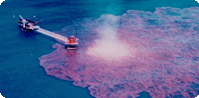
Juerg Lichtenegger, ESRIN/ESA, showed us the possibilities of using radar satellites in the detection of oil spill at sea. He told about ERS-1 (operating from 1991) and ERS-2 (still operational). He showed a lot of images explaining the various difficulties of separating oil spill from other phenomena on the sea surface. The main origins of oil spills are: fixed installations, ships at anchor, catastrophic oil spills and vessels along main shipping routes.
He talked about former and existing projects for detecting and treating oil spills in the Mediterranean. Each point in the surveyareas in the Aegean Sea and outside the Spanish east coast is covered once a week by ERS images. With the new satellite ENVISAT and the Canadian RADARSAT in addition, there will be a daily covering of each location. This will increase the possibility of having an effective, automatic early warning of oil spill. Using SAR images from the radar satellites one can detect suspicious slicks each day. It is also very important to be able to confirm if the slicks are real or just look-alikes, as soon as possible after the first detection. Therefore short reports describing the situation should be sent to the responsible authorities immediately. Fax is a convenient way of giving fast reports. ENVISYS should have tools for automatically sending of fax reports.
When report of a suspicious slick is received, observators should be sent to the given location as soon as possible by airplane, helicopter or ship to confirm the observation and to try to detect the origin of the oil spill.
It is also important to compare images taken from satellites and/or planes at different times to see how the slick is moving. It may crucial to have a good cooperation with the meteorological authorities in order to receive information about the existing weather conditions as well as updated weather forecast. This will help in the prediction of the development of existing oil spill. The conditions of the sea surface is influenced by wind, currents and precipitation that may complicate the detection of oil slicks. Therefore, weather information is also extremely helpful in the interpretation of SAR images.
ENVISYS - a solution for oil spill counteraction
The ENVISYS concept for environmental management
Rune Solberg, NR, gave a description of ENVISYS in detail and showed how the developed parts can be used in future systems for surveillance of forest fires, floods and earthquakes.
ENVISYS demonstration in Greece
Spyros Pantelis, INTELLSERVE, described the situation in Greece. He gave examples of detected oil slicks where nearly half of the slicks where of unknown origin. To find the origin, an early detection is essential.
He told about the existing outfit to control and reduce the damage of oil slicks to the environment like fisheries, beaches, aquacultural plants and tourist facilities.
Giannis Economou, INTELLSERVE, gave a short review of the system showing how wind and sea current data can be automatically imported and used in ENVISYS. The meteorological data are prepared in collaboration with the University of Athens, IMPAE (Institute of Physics in Athens) and NOA (National Observatory of Athens).
INTELLSERVE has set up a demonstrator for the survey area in the Aegean Sea. This is not a real time demonstrator, as images from october-november 1998 and january-february 1999 are used. But the procedures of a real time system are followed, and reports are sent to ANETKY.
In the future, a real time system will be operating in the area. The aim is to produce a report 1-2 hours after the image acquisition. This will probably be OK, even if there are many islands and short distances between the islands.
A series of SAR images were presented, with examples of problem images, which once again demonstrated that the detection of oil slicks can be a serious problem.
There was a discussion about the problems of finding the origin of the oil slicks. When a ship is emtying its tanks, it is essential to have an image as soon as possible afterwards to be able to connect the oil slick to the ship and to be able to get evidence that can be used in court. We have only a few examples of bringing a oil spill case to court, because of late detection. There are some differences between the countries in the type of evidence necessary for suing a captain for oil spill. In France it can be enough with a picture of the oil slick and ship, where the ship can be identified. In Greece and Spain you also need a sample of the slick to be able to compare the oil with the contents of the tanks of the ship. Therefore, it is important to have an early detection.
ENVISYS demonstration in Spain
Carlos Marti, INDI, gave a presentation of the Spanish demonstrator. He described in particular the problems along the Spanish coast. There are several areas sensitive to oil pollution, beaches, fishing regions and natural reserves with birds and plants. He mentioned the problems with wind and sea current data. It is very important to have frequently updated data to be able to predict the development of an oil slick.
The user experience with marine oil pollution
Protection of the environment in the Aegean Sea
Dimitris Mpougas, ANETKY, talked about the experiences in the Cyclades. The most important tasks are:
- Securing the areas against oil spill pollution.
- Tracking the worst dumping.
- Catch the polluters.
Vessel pollution in Spain
Miguel Perez Marrodan, ISDEFE, was speaking in the place of Javier Villanueva, Directorate General of Marine Merchant. It is very important to try to solve the problem of illegal dumping of oil. The administration must find the polluters.
Procedures of marine pollution control in Spain
Juan Carlos Crespo, SASEMAR, discussed the problems of clenaup operations in the Spanish waters. There are three areas to survey: The Atlantic, the Strait and the Mediterranean. Spain cooperates with United Kingdom, Ireland, Morocco and Portugal in rescue and security operations in these areas. A video showing how SASEMAR is working was presented
March 23.
Environmental monitoring and management in general
European activities for detection, management and documentation of floods
James Dent, H.R. Wallingford, gave an extensive presentation of the problems and possible solutions of detection, management and documentation of floods. He presented examples from England and also larger European cooperation projects.
In England one is collecting data about floods from the last 200 years. This will give valuable statistic data for future forecasts of new floods and the development of floods.
LIDAR is a new and effective tool for registration of flood-laid areas and areas exposed to floods. It is cheaper and faster than photogrammetry.
For forecasting of floods, images from weather satellites are of great value. It is important to be aware of weather fronts and temperature. Information about the snow cover can also be found by satellite images. Weather radars can give locational and quantitative rainfall information. Telemetry of water level and rainfall give valuable information.
One problem is that many institutions are involved in the collecting of data. It is important that data are distributed effectively to the responsible authorities. When the flood has started, one usually gets messages from people at the place. Then LIDAR is an effective tool to survey the flooded areas. One should be aware that telemetry systems may be knocked out by the flood. Another problem, difficult to forecast, is that rivers may be partly blocked by avalanches due to the flood.
Some international projects were described. The institutions in the participating countries are using different hydrological and hydrodynamic models.In RIBAMOD, a project in the 4th frame programme of EU, it was tried to join the existing models together in a common system. In EUROTAS one is aiming at a development and demonstration of catchment models for five rivers in Europe. The challenge in addition to the different practice in the separate countries, is the large difference in scale of area and time. The Elbe has a total catchment of 120 000 km² and a subcatchment of the Thames is only 100 km².
The operational hydrologists dream is a complete and effective GIS where all models and input data can be treated and the results presented in a descriptive way.
Forest fires - reasons, effects and how to prevent it
Luis Velasco, Generalitat Valenciana, was talking about forest fires, the reasons, effects and how to prevent it. He presented statistics showing the origins of forest fires. There are uninteded causes, where smokers or children have started a fire by accident. In some cases the fire has been started on purpose, for example by burning of underbrush, where the fire has come out of control. Fires started by lightning covers a reasonable high percent of the cases.
The result of a forest fire, depends largely on the type of area. It is important to try to restore the vegetation as soon as possible. If the vegetation is not restored, you will get problem with the water. Without or with scarce vegetation the water will easily pass away, and may cause damage due to erosion.
Discussion groups
Moderator: Mr. Espen Volden , Norwegian Computing Center
Participants:
Mr. Pedro Cano, SASEMAR, Madrid
Mr. Javier García García, SASEMAR, Barcelona
Mr. Fernando Vázquez , SASEMAR , Gijón
Mr. Santiago Simón , CRONOTECK
Mr. Lichtenegger, European Space Agency
Ms. Isabel Comós, IN&DI, S.L.
The objectives of the discussion group were to know the participants' opinion about the Envisys system and ideas for the amelioration of the system. The user needs were essential in the debate.
For SASEMAR it is important to receive information about the position of the oil slick, the oil characteristics, information about wind conditions and also to receive the image.
SASEMAR now receive warnings about oil spills from accidental observations from the coast or from ships. To verify the information they use boats and helicopters.
Mr. Santiago Simon said that the Envisys system was not efficient because they don't get images as often as they want. A weekly coverage is not sufficient.
SASEMAR said that they were interested in having the system in their office.
Mr. Pedro Cano said that Envisys is an excellent tool. However it is necessary to get the opinion of the entire SASEMAR direction, about which system is the best. They want regular information about the Envisys progress.
Mr. Lichtenegger emphasised to take into account a budget to pay the satellite images.
SASEMAR explained that they have a training simulator developed by a Norwegian company .
Floods
Participants:
Mr. Miguel Alborg Domínguez, IDIEIKON, Valencia, Spain
Mr. James Dent, HR Wallingford, UK
Mr. Luigi Fusco, ESA/ESRIN, Italy
Mr. Fernando Garcia-Belenguer, ISDEFE, Spain
Mr. José F. Moreno, University of Valencia, Spain
Mr. Spyros Pantelis, INTELLSERVE, Greece
Dent: It is difficult to maintain the information up to date.
Meteorological information is quite expensive.
Remote sensing is a complementary information to ground information.
Fusco: With ERS-1 and 2, Radarsat and Envisat satellites there will be daily information. At the present moment, the information is available every 2 or 3 days.
Ground information will always be necessary.
He mentioned that in 1995 they obtained information on a specific flood in France the day before and the day after.
Dent: sensors can be used to calculate moist in the watershed.
It is possible to measure the height of the water sheet; it was done in the Aimwater project, Paris, France.
Fusco gave a brief description of a number of other relevant projects.
Moderator: Mrs. Laura Meliá, IN&DI, S.L.
Participants:
Mrs. Monserrat Rodriguez, Protección Civil de la Comunidad Valenciana (Fire Extinction)
Mr. José María Uñon, SEMA GROUP, S.L.
Mr. Rune Solberg, Norwegian Computing Center
Mr. Luís Velasco, Jefe del Area de Servicios Forestales de la Comunidad Valenciana (Fire Prevention)
The aim of this debate group was to determine the needs of the end users as well as the opinion about the ENVISYS concept.
Luís Velasco and Monserrat Rodriguez thought the ENVISYS concept is good for the future but not at the present, due to the limited coverage of today's satellites.
Rune Solberg talked about new satellites and sensors that will greatly improve the coverage: the MERIS sensor of the European ENVISAT satellite which is scheduled for launch early 2000 and the MODIS sensor of NASA's satellite Terra (previous EOS AM-1) which is scheduled for launch in July 1999.
Mrs. Monserrat explained that the Fire Prevention service receives daily a meteorological report of the risk index.
José María Uñon showed a system created by an international consortium for the Fourth Framework Programme. The features of this system are as follows:
- It was created using Arc View GIS.
- It's not on real-time.
- It has planning in the medium term and scenarios. The system combines them and it does the simulation.
- It is based on historical data (five years). It is a system based on the probability (it tells you the fire probabilities, not where the fire is located or where it will be).
- It's been used by the Spanish municipality Galicia.
Rune Solberg and José Maria Uñon discussed the possibility of a future cooperation.
Espen Volden, NR, demonstrated first the ENVISYS system by a quick simulated demonstration.
Finally the system was demonstrated on an ENVISYS work station, and the participants were able to run ENVISYS by themselves.
Key speakers:
James E. Dent - HR Wallingford
Luigi Fusco - ESA/ESRIN
José F. Moreno - Dept. Thermodynamics, Faculty of Physics, University of Valencia.
Espen Volden - Norwegian Computing Center
- James E. Dent:
Internet and Intranet: the better ways to communicate.
What kind of data do we need for the different applications?
Two things we see after this conference:
- Improvement of coverage is important
- How we can find a focus of application of these tools.
The exchange of data or information between countries may be difficult for many reasons (political, bureaucratic,...) and remote sensing of satellites often provides a way of obtaining such data from another country.
When the end users would feel that remote sensing is useful for them maybe then they are ready to pay.
- José F. Moreno:
We are quite far away to have the requirements for forest fires. There is a big void to cover on this.
The point is what kind of information we can get from the data. In some cases the problem is that we don't really know it or that you never will get all this information from that source. You need other ones. The integration of data from different sources is important. Could be interesting to think that in the future we will have better information due to better sensors will be lanced. This will able us to get more useful this kind of technologies.
New sensors, new satellites and new technologies will open up a lot of possibilities. We must be ready for this.
- Luigi Fusco
Market perspective: The big market is outside of Europe. Asia is a potential market
We must to get the Civil Protection Authority through the Service Industry and not in the opposite way. This is the model.
Mr Fusco presented the RAMSES project.
We must give to the user only the information that he needs, provide him with information, not data. We must talk the same language as the user. The user doesn't know much about satellites. That's the experience from the RAMSES project.
- Espen Volden
The problems that the users stress are the limited coverage of today's satellites and the time of delivery. However these problems have been greatly reduced in the last years and this tendancy continues. For SAR images a daily coverage of the Mediterranean will be possible with the combined use of the Canadian RADARSAT (already operational) and the European ENVISAT (planned for the year 2000).
With ENVISYS the user has the option to either receive only the information he needs, which is the output of the ENVISYS system, or buy the images and process them himself using ENVISYS.
A monitoring system based on satellite images with a frequent and extended geographical coverage may be expensive compared to a more classical monitoring service with an uncomparable coverage (in space and time). However if you already have an extensive monitoring based on aircrafts, changing partly to satellite images may even reduce the costs, like the experince from Norway show. ith Some countries already had monitoring systems such as Norway (aircraft) and nowadays they have SAR satellite images. Increasing concern about the environment may impose obligations to have a certain level of monitoring. In that context, when the choice is not whether to use ENVISYS or nothing, but between ENVISYS and a monitoring system that does not use satellite images, then ENVISYS may be best economical solution.
- Open discussion:
- The Spanish administration replaces the operating system they have working now by the new monitoring system. If the new one doesn't work the Spanish administration will have to pay again the old one.
- The Spanish administration keeps the current system and takes the new one as well. So in this way it is paying two systems (too expensive).
José Maria Uñon - SEMA GROUP:
Solution: The complementation of the system.
José F. Moreno:
If there is an error of for example 2km. and you send the people over there this would be even worst than using the traditional system. So if the remote monitoring system is not perfect will be terrible thinking about the economical point of view and the public opinion if there are kinds of mistake as in the example.
James E. Dent:
If you cannot provide the service, you loose the user's confidence.