Main activities
Main activities
Field measurements
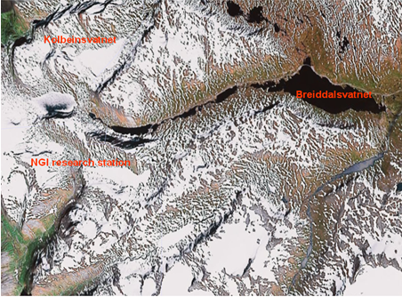
Data from four test sites have been studied so far. Three sites are located in the Strynefjell mountain range, Western Norway (see figure below). On these sites it is possible to get satellite data without signals from vegetation, roads or other objects into the field of view for at least one MODIS pixel. However, due to the alpine terrain, topography will influence the signal measured by the satellite sensor. Two test sites (Fonnbu and Grasdalsvatnet) are located in Grasdalen, close to the snow and avalanche research station Fonnbu of the Norwegian Geotechnical Institute (NGI). The third test site is situated at Breiddalsvatnet, a lake on the eastern side of the Strynefjell mountain. Here, the effects of the topography are eliminated. The test sites in the Strynefjell mountain range are quite far from the premises of the research institutes, which in practice limits the number of field measurements that can be taken during the snow season. Therefore, a fourth site in the Oslo region (close to Lillestrøm) was added in order to allow for quick response for fieldwork when the weather permits satellite data acquisition. The site is located in a flat agricultural area situated about 30 km north-east of Oslo, thus eliminating topographic effects.
Strynefjell mountain range with our three test sites indicated (Landsat TM image)
Data analysis
Retrieval and analysis of Fractional Snow Cover (FSC), Snow Temperature for the Surface (STS), Snow Grain Size (SGS) and Snow Surface Wetness (SSW) from MODIS data has been done for the two snow seasons 2007-2008 and 2008-2009. The darkest part of the snow season (in particular December and January) gives somewhat unreliable results due to low solar elevation. Two cases of particular interest were found in the 2007-2008 dataset and two cases in the 2008-2009 dataset. The observed SGS increased over a few days (typically 2-3 days), while STS decreased. Due to the lack of simultaneous field measurements, it was not possible to confirm that these cases represent surface hoar. However, in one case surface hoar was observed coincidentally at Norefjell, and an analysis of corresponding satellite data from Norefjell showed an increase of SGS over a few days. The measurements in Lillestrøm started too late in the season to observe surface hoar. However, variable grain size was measured in the field with corresponding variability in SGS. These data can therefore contribute to the establishment of an accurate relationship between observed SGS from satellite and snow grain size and shape as measured in the field. For further studies of snow surface properties measured from satellite, and in particular the development of surface hoar, we will increase the number of in situ measurements significantly to get a reasonable chance of obtaining simultaneous measurements in situ and by satellite.