Some results
Some results
Validation of automatic classification
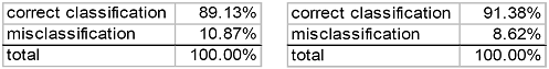
The result of the automatic classification was validated by selecting six areas randomly, each cosisting of 1000 x 1000 pixels. For each area, a copy of the classification result was edited manually, and then compared with the original classification result. This resulted in the below classification rates.
Left: Classification result when using six classes. Right: Classification result when using two classes.
The most common misclassification is to confuse little vegetation and grey areas. About 5% of the pixels were misclassified in this manner. The classification results show that the classification part of the automatic algorithm is able to classify between green and grey areas, with approximately 10% misclassification. This is clearly a good starting point for improvements. However, the segmentation step created very rugged object boundaries. This observation suggests that the segmentation step of the automatic algorithm has a great potential for improvement. The results of the segmentation step are not directly available to us in the classified image, since neighboring segments in many cases have been assigned the same class in the classification step. From the classification result, it is obvious that the object boundaries of classified grey areas deviate substantially from the true outlines of houses and roads. This is especially true in suburban areas, where there are a lot of small roads and buildings.
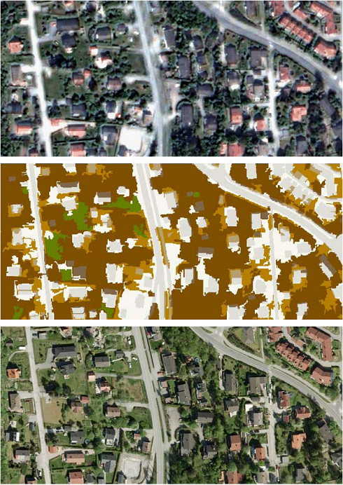
Segmentation problems in suburban areas. Top: a 330 m x 250 m part inside validation area 1 of the Pansharpened Quickbird image. Middle: the automatic classification result for this subimage, with houses and roads from a digital map superimposed in grey. Bottom: Aerial orthophoto of the same area, captured with 10 cm ground resolution.
Many of the segmentation problems are due to shadows from buildings and trees. House shadows are sometimes misclassified as grey areas. Tree shadows are sometimes mistaken as grey areas, and other times they block grey areas.
.png)
Examples of house shadows that are misclassified as grey areas. Top row: classification result, with roads and buildings superimposed in light grey. Bottom row: pansharpened Quickbird image.
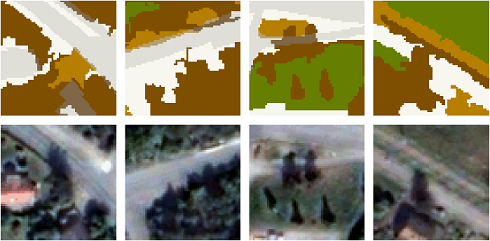
Examples of tree shadows that are misclassified. Far left and middle left: tree shadows that are mistaken as grey areas. Middle right and far right: tree shadows blocking grey areas. Top row: classification result, with roads and buildings superimposed in light grey. Bottom row: pansharpened Quickbird image.