Methods
Methods
Hidden Markov model
.gif)
Tropical forest monitoring in Tanzania is challenging due to frequent, partial cloud cover. Also, there are large seasonal variations, due to the rain seasons and dry periods. This means that detecting forest changes simply by classifying two satellite images taken a few years apart, and compute the difference, will not work well in practice.
We propose to use a hidden Markow model approach to address these and other challenges in order to do forest mapping and forest change detection. The method is based on using a time series of images; the more images, the better.
.gif)
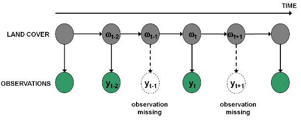
In the hidden Markov model, each satellite image pixel is modeled as an observation of an uknown state of the corresponding area on the ground. This has two major benefits:
- Modeling of seasonal variations: forest changes are detected as changes to the expected variations.
- Straightforward modeling of missing observations due to partial cloud cover: if a pixel is cloud covered, then the observation of the pixel is flagged as missing (see figure below).
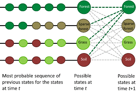
The hidden Markov model is tuned by defining transition probabilities between each of the states.
![]()
Then, it computes, for every pixel, the most probable sequence of states.
This means that the approach may be more robust to noise than methods working on single images, or a single, minimum cloud cover mosaic.
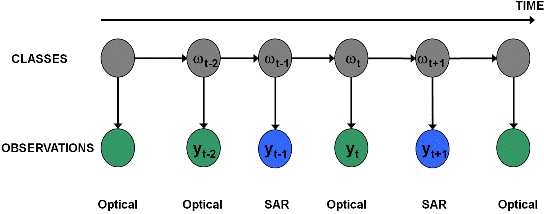
An alternative to using optical satellite images is to use radar (SAR) images. Although optical images are more straightforward to interpret visually by humans, radar images have some advantages:
- SAR images are much less affected by cloud cover.
- L-band SAR images (24 cm wavelength) are able to penetrate through leaves and thin branches (typically everything smaller than half the wavelength) and capture tree trunks and thick brances.
However, rather than using SAR images instead of optical images, they can be used in combination. The hidden Markov model is well suited to accept a mixture of optical and SAR opservations.
Tropical forest monitoring in Tanzania has additional challenges, which will be addressed in the project:
- There is often no distinct boundary betweeen forest and non-forest. Rather, there is a gradual transition from closed forest to open woodland and savannah.
- Much of the forest loss is a gradual process. Still, there are some sudden forest changes as well, due to clear cuts and fires. There is also forest regrowth and forest plantations.
- Agriculture sometimes includes woody crops
The historical archive of optical satellite images covering the entire Tanzania is mainly based on Landsat images, with 30 m ground resolution and 16 days revisit time (if cloud cover permits). However, the methods will take advantage of new satellites with better resolution, including RapidEye (5 m resolution, since 2009) and Sentinel-2 (10 m resolution, from 2013). Very high resolution satellite images from Worldview-2 (2 m) and Quickbird (2.4 m) will be used for calibration and verification of methods.
.jpg)
Worldview-2 image. Left: the entire image. Right: a small portion, approximately 900 m x 600 m on the ground, covering open land with scattered trees and a part of the Nilo Forest Reserve, Tanzania.