Background
Background
The Government of Norway has entered into a bilateral agreement with the Government of Tanzania on Climate and Forest. The overall goal of this agreement is to achieve reductions in greenhouse gas emissions from deforestation and forest degradation in Tanzania. The introduction of a functioning Measuring, Reporting and Verification (MRV) system that meets the UNFCCC’s reporting requirements is a vital part of this agreement.
Nation-wide forest cover change monitoring in countries the size of Tanzania needs to be based on automatic processing chains. Whenever new satellite images are available, they should be processed to provide updated estimates of deforestation, reforestation, forest degradation and regeneration.
The Norwegian Computing Center (NR) is involved in two major work packages in this project:
- Delivery of preprocessed satellite data and development of preprocessing methods
- Mapping of forest area and forest area change
The pre-processing of optical images includes atmospheric correction, cloud and cloud shadow detection and masking, and co-registration and terrain height correction. Forest change detection is based on a hidden Markov model. In this context, “hidden” refers to the fact that the true land cover state for each location on the ground is unknown, but observations are available as a time series of satellite image pixels. Given the observations, the most probable sequence of ground cover states is determined. From this, forest state changes, say, from “forest” to “non-forest”, can be found to have occurred between two observations. Due to varying cloud cover across a scene, and missing pixels (SLC-off) in Landsat 7 due to sensor failure, the different pixels may have different time series of observations. The hidden Markov model automatically compensates for this. However, the accuracy will increase with more observations, so it is important to have access to a dense time series of past observations, and guaranteed access to future acquisitions at regular and relatively short time intervals. The upcoming Landsat-8 and Sentinel-2 optical satellites will be important in this respect.
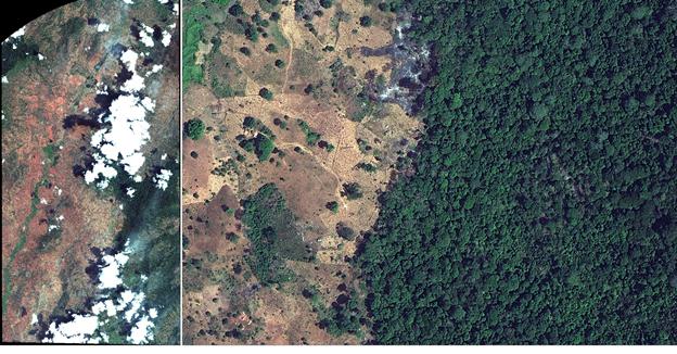
Worldview-2 image. Left: the entire image. Right: a small portion, approximately 900 m x 600 m on the ground, covering open land with scattered trees and a part of the Nilo Forest Reserve, Tanzania.