Snow Service Evaluation
Snow Service Evaluation
The accuracy of the automatically produced snow cover area maps is discussed in Solberg et al. 2004a, Solberg et al. 2004b, Solberg et al. 2005 and Storvold et al., 2005. In general the best results, with an accuracy of around 90%, are obtained with optical data under cloud-free conditions. With SAR data the accuracy is around 85% but with the advantage of being unaffected by cloud cover.
The service evaluation comprises three elements:
- Evaluation of how well the service meets the user requirements
- Validation of the technical quality of the service
- Validation of the accuracy of the products
Task 1 is performed in close co-operation with the user group. The impact of the FSC product on the final products produced by the users will be assessed, as well as the identification of further product requirements.
Task 2 focuses on technical robustness, security issues, user friendliness, maintenance, etc.
Task 3 compares the geophysical variable in the product with reference data (high resolution optical data from satellites and aircrafts for FSC validation).
Task 3 has been carried out as far as practically possible in the pre-operational projects prior to this service. For this project Tasks 1 and 2 will take place after each snowmelt season. A service upgrade plan is prepared based on user feedback from tasks 1 and 2. The service is then upgraded and improved in preparation for the next melt season. Quality parameters covering the accuracy and delivery are defined and implemented based on consultation with the end users.
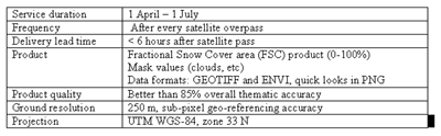
The service performance targets are listed in the table below.