Project work
Project work
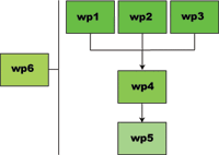 The project is divided into activity units - so called "Work packages" Each work package is divided future into tasks. For the SnowMan project, the following packages have been defined.
WP1: Optical remoter sensing of snow parameters
Development of methods for estimation of snow parameters from optical data: Accurate snow-cover-fraction estimation at the sub-pixel level, albedo, snow wetness and, if possible, accurate free water estimation.
Snow reflects sunlight in an anisotropic manner with strength depending on the snow's metamorphosis stage. A result of this is that sub-pixel snow fraction estimates may be affected with large errors as long as the local illumination-observation geometry and the current anisotropic behaviour of the snow is not taken into account. The anisotropic behaviour of snow has been studied in several works at various scales based on field, airborne and spaceborne measurements. Various models have been made. However, the model is limited to a single snow situation (metamorphosis stage).
Due to the need for frequent temporal coverage, medium-to-low spatial resolution sensors often have to be applied and accurate snow-cover fraction estimates have to be derived at the sub-pixel level. Spectral features have to be analysed in order to estimate the contribution of each surface type to a pixel’s spectrum. This is not an easy task due to the ever-changing spectra of snow (due to variable contents of impurities and the state of snow metamorphosis) and bare ground (due to the natural development of the vegetation when snow has left and natural variability of other surface types). Mountainous terrain makes this task even more difficult due to the local illumination geometry and the atmosphere attenuates the spectra when measured from a satellite. Most algorithms applied for snow cover classify a pixel into one class only. Common approaches are unsupervised algorithms. There are also hybrid algorithms, which have been used successfully for snow mapping. Box classification, usually physically motivated algorithms, is also widely applied. A simple linear sub-pixel algorithm has been applied extensively in Norway since it was invented. Later, spectral unmixing has been tested with success in several experiments by scientists at University of California, Santa Barbara. Spectral unmixing is currently one of the most accurate algorithms. However, it is supervised and very time consuming. A new approach to spectral unmixing has been proposed. The method measures certain features in potential endmember spectra in order to predict the actual endmembers and the amount of them (e.g., snow cover area). The method is so far only tested on spectrometer data.
Tasks
Temporal anisotropic reflectance model
An empirical temporal spectral BRDF model for snow will be developed taking into account anisotropic effects and metamorphism. The model will have as input the at-satellite spectral reflectance, a modelled atmospheric attenuation of the signal, a digital terrain model, the snow grain size and the content of impurities. For partly snow cover, a snow cover map and the background spectrum of the bare ground will be used. Most of the data material will be collected through one or more winter seasons measuring snow BRDF with a goniometer together with other snow parameters. The data will be integrated into a multidimensional parameter model and approximated by analytic functions (e.g., splines). The model will have a broad application area within snow hydrology and climatology. Within this project, the model will be applied in the fractional snow-cover-area algorithm. The new BRDF model will be developed for and tested on data from various satellite sensors, in particular MERIS, AATSR, MISR and MODIS.
Optical snow cover fraction
An algorithm suitable for operational applications needs to be unsupervised. It also needs to handle mountainous terrain and the ever-changing spectral signatures of snow and bare ground. It has to be robust and accurate, and it should also be able to utilise the maximum spatial resolution of the available sensors in order to compensate for terrain heterogeneity. Based on the work by Solberg (2000a), the project will develop an unsupervised spectral unmixing algorithm, which takes into account the topography, compensates for atmospheric effects and applies temporal BRDF (Bi-directional Reflectance Distribution Functions) evolution models for snow and bare-ground spectra. The algorithm will utilise that new and near-future sensors have more spectral bands, but without being tailored to specific sensors (generic approach). A novel approach to subpixel topographic correction, utilising the observed effect from the topography when snow type and illumination geometry is known, will be investigated. Atmospheric correction will preferably be based on data from a dual-observation angle sensor that flies on the same platform (MERIS with AATSR and MODIS with MISR). A library of endmember spectra or endmember spectra models is required and will be developed.
WP2: Rader remote sensing of snow parameters
1. sensor parameters which includes fre-quency, polarization and viewing geometry, and
2. snowpack and ground parameters which includes snow density, liquid water content, particle size and shape of water and ice, and surface roughness parameters.
For a dry snow covered terrain the small absorption coefficient allows the microwaves to propagate in depth and generate volume scattering from the snow pack and scattering from the snow-ground interface. As a first approximation dry homogenous snow is transparent at C-band and the main scattering component is from the ground. This has been supported by several ground based signature measurements campaigns. In a wet snow cover the microwaves are absorbed in the top layer and surface scattering, is the main scattering mechanism. Surface scattering is determined by the electromagnetic properties of the medium and the structural proper-ties of the surface, surface roughness. Several attempts have been made to develop snow-scattering models which predict sensor response for a given set of physical parameters that is assumed to constitute an accurate description of the target. The models do not describe the full range of microwave observations and snow parameters. Recent progress in extending the Microwave Emission Model of Layered Snowpack to include backscattering seems to represent an important tool for understanding the interaction of synthetic aperture radar with snow and ground.
It is now well established that estimate of snow cover area of wet snow can be obtained from airborne synthetic aperture radar sensors , and spaceborne sensors such as ERS and RADARSAT synthetic aperture radar. In mountainous areas the topography significantly affects the geometry and radiometry in the synthetic aperture radar image, thus geocoding and calibration using digital elevation models are required in order to relate the data to signature data and to avoid areas corrupted by folding and layover. Enhanced snow cover area-mapping accuracy has been obtained by using coherence derived from repeat pass interferometric synthetic aperture radar data in addition to intensity only information. By using multi- frequency and polarisation synthetic aperture radar instruments enhanced snow mapping capabilities have been demonstrated. In analysis of both airborne polarimetric C- and L- band data and Radarsat the highest contrast between bare ground and wet snow was found for high incidence angles. Bernier et al., (1998) indicated the possibility to derive snow water equvivalent from dry snow using single parameter synthetic aperture radar data. Also, the snow water equivalent increase measured from January to March 1999 was clearly detected on the maps covering almost 77 000 km2 (Bernier et al., 1999). The radar wave will be refracted in the snow and the amount of refraction is proportional to the snow density since the dielectric constant for dry snow depend solely on the density (Mätzler 1996). It has been shown that only small changes in SWE between two interferometric SAR images changes the interferometric phase. It has also been shown to affect the differ-ential interferometric SAR phase in ERS Tandem data, leading to an “apparent” range displacement which is related to changes in SWE (Guneriussen et al., 1999d-e). Since the contrast between bare ground, dry snow and wet snow is very sensitive to the liquid water content, SAR data can be used to detect snowmelt onset dates, as shown for multi year sea ice by Winerbrenner et al., (1994). Snowmelt onset estimates over snow-covered ground has been obtained from time series of geo-coded and recalibrated RADARSAT data (Guneriussen et al., 1999b). The temporal and spatial accuracy of the estimates depends to a large degree on the satellite temporal coverage. An algorithm for estimation the volumetric content of free water in the top layer of the snow, snow wetness (SW), has been proposed using C-band HH, VV and HV polarisation (Shi, 1995). Experiments using the shuttle imaging radar C- and X-band SAR (SIR-C/X-SAR) show accuracy in the order of 2.5% in the wetness range 2-15%. Independent tests of the algorithm gave fairly impressive results, even if some basic assumptions about the algorithm were difficult to justify (Kendra et al., 1998).
Tasks
Snow cover area
An algorithm suitable for covering large areas like southern parts of Norway (200.000 km2) needs to be unsupervised. It also needs to handle mountainous terrain and the varying signatures of snow and bare ground. The optimum ENVISAT ASAR instrument configuration (incidence angle and polarisation) for various snow conditions will be determined using the dual-polarization and multi-angle-of-incidence capabilities of ASAR. Several repeated SAR and ground truth measurements acquired from selected test sites, as part of an ENVISAT AO accepted proposal during the period 2001-2003, will be performed. More robust algorithms for SCA mapping using combination of ASAR VV and HV images will be derived and validated against high-resolution optical data and in situ data. The signature database developed in the SnowTools project (Hiltbrunner et al., 1997) and the “extended” Microwave Emission Model of Layered Snowpack (MEMLS) (Mätzler et al., 2000) will be used. Temporal analysis and comparison with signature data requires fully calibrated and precise geolocated SAR data. This will be achieved by extending the software for geocoding and calibration of RADARSAT, ERS and EMISAR data (Johnsen et al., 1998) to handle ENVISAT ASAR data. The value of including coherence derived from ASAR interferometry data in the SCA classifier will be investigated. The SAR instruments ability to discriminate between various snow conditions depends to some extent on the vegetation class and the algorithms for snow-cover estimation must also handle forested areas.
Snow water equivalent
The positive correlation between SWE and C-band polarimetric EMISAR data over non-forested relatively flat areas found by Arslan et al., (1998) will be investigated for mountainous areas. We will use the fully polarimetric C- and L- band SAR data, in-situ data and ground penetrating radar data from Kongsfjellet acquired as part of EMAC’95 campaign. The satellite SAR data acquired in Task 2.1, ground penetrating radar and in situ data will also be used to study the relation between SWE and backsattering properties. The “extended” Microwave Emission Model of Layered Snowpack (MEMLS) (Mätzler et al., 2000) will be used to relate the observed backscattering values to the predicted one based on the snow pack properties parameters. The interpretation of InSAR data from snow-covered areas will be addressed. This will deal with the problems of the scattering mechanism, scattering centre location, and refraction in snow pack and loss of coherence. The observed relation between the “apparent” range displacement in tandem ERS interferometric SAR data and SWE of dry snow will be further studied (Guneriussen et al., 1999d). Correlation analysis between ASAR altpol data (VV VH), in situ and ground penetrating radar estimates of SWE will be performed. Interferometric SAR derived coherence will be used as an indicator of snow/ground property changes. The sensitivity of ASAR for detecting changes in SWE will be determined.
Snow wetness
An algorithm for utilising the dual polarisation capabilities of ENVISAT SAR data will be developed for determining the onset of snowmelt. The spatial and temporal accuracy will be determined by analysis of corresponding snow, meteorological and remote sensing data acquisition. In particular the co- and cross-polarisation temporal backscattering characteristics for different snow and land-use categories will be used to determine how accurately the snowmelt onset can be determined.
WP3: Multisensor data and field campaigns
Tasks
Multisensor and multitemporal algorithm for snow cover area
The multitemporal/multisensor concept is quite clear in advance. At least one optical sensor and a SAR sensor will be combined in a time series. Priority is given to the optical sensor (clear sky). The SAR sensor will only be used in the snowmelt season. Mountainous topography with elevation-dependent air temperature will be used to infer dry snow at high elevations in SAR data. A multisensor classification algorithm for snow may be based on one of the general methods developed (see above), but need to be extended with a sensor priority scheme and has to handle the special characteristics of each sensor type. Since such an approach, building on a theoretical correct multisensor model, for snow-cover mapping has not yet been investigated before a comprehensive investigation will be necessary. Varying terrain, illumination and weather conditions may create variability that is not due to variations in the snow cover. In case of divergence between the sensors, the reasons must be investigated and corrections must be included in the algorithm.
Multisensor algorithm for snow wetness
A multisensor algorithm will be developed combining temperature measurements from a thermal sensor with measurements of free water in the snow surface from an optical sensor and the presence of free water accurately detected by a SAR. The combination of the three approaches should make the prediction of snow wetness robust. The temperature algorithm includes accurate modelling of the atmospheric effects on the temperature brightness under the given geographic conditions. Furthermore, the algorithm will be extended to utilise a snow-cover map to correct for bare ground temperatures at the sub-pixel level. The liquid water algorithm, based on molecular absorption, will be modified to enable various sensors (generic approach) and then be verified on spaceborne sensors. The algorithms will be developed and verified on data from spaceborne sensors, including AATSR, MISR, ASTER, MODIS, MERIS, ASAR and Radarsat.
Remote sensing data acquisition and field campaigns
Remote sensing data are needed in all work packages. Additionally, field measurements are needed together with the remote sensing data for the development of algorithms and verification. The most cost-effective approach for the project is a co-ordinated approach with common field campaigns collecting data for several work packages simultaneously. The overall plan is to collect data through four winter seasons with the following focus: Field campaigns for development of algorithms in 2001-2002; Field campaigns for verification and demonstration purposes in 2003; and Field campaigns for demonstration purposes in 2004. The Heimdalen test site, Jotunheimen, will be used in the first two campaigns. The test site was established in the SnowTools EU project and several datasets exists (ADRO, DAIS etc) (Guneriussen et al., 2000a). The reuse of the site results in a significant saving of costs. The two last campaigns need a larger area, but not that much ancillary data. The main focus will be on the following sensors (note that many of the algorithms will be of generic nature but have, for practical reasons, to be limited for testing on about 2-3 sensors in this project): ENVISAT with MERIS, AATSR and ASAR; Terra-1 with MODIS, ASTER and MISR; and Radarsat. ENVISAT data will be acquired through an accepted ENVISAT AO proposal. A field campaign will typically measure the following parameters: Density (surface for optical, vertical profile for SAR); Wetness (surface for optical, at sampled depths for SAR); Water equivalent; Snow-pack structure (for SAR); Snow surface and air temperature; Depth; Snow grain size (surface for optical, vertical profile for SAR); Snow impurities (for optical); Snow surface roughness (for SAR); Spectral (anisotropic) reflectance (for optical); Snow cover (aerial photography); and Bare ground brightness temperature (for thermal optical). Ground penetrating radar system will be used for acquisition of SWE data from larger areas within a catchment. Typical ancillary data needed are: Digital terrain model; Ground surface map (vegetation etc.); and Temperature measurements from nearby meteorological stations. Field teams will be composed of experienced personnel from all the participating organisations.
WP4: Integration of snow parameters in hydrologic models
Algorithms will be developed to implement the snow parameters derived from WP1, WP2 and WP3 in both a lumped and a distributed hydrological models.
It has been shown that the lumped HBV model has a great parameter uncertainty (see i.e., Tøfte, 1999). This uncertainty will be reduced by use of additional snow information in the calibration (Seibert, 1997). Nevertheless, the model is traditionally calibrated against runoff and the simulated snow conditions in the model are not necessarily compatible with the true snow conditions (see i.e., Häggstrøm, 1994). Operational use of satellite derived snow parameters in the HBV-model has not been reported and only a few authors have reported operational applications of remote sensed snow parameters in other models (Rango and Shalaby, 1999). However, some studies have been performed in Norway and Sweden connected to updating of the snow variables in the HBV model, which is the most used hydrologic model in water management in these countries. Automatic updating for a single catchment has been reported by Johansson et al., (2000). The results from this work showed that the simulations could be improved by integrating SCA derived from satellite images. A condition for this improvement appeared to be calibration of the model against SCA in addition to runoff. This condition is supported by the works of Lindström (2000) and Kolberg and Tøfte (2000) who show that reducing the calibration freedom, by validating the model to observed SCA, improves the simulations and reduces the uncertainty. Good routines for updating the areal distribution of the snow water equivalent are still not established, but a method based on satellite derived SCA and the frequency of snowfall events (Skaugen 1999) may lead to improvements. Regional hydrological modelling implies a repeated use of a model everywhere within a region using a global or regionalized set of parameters. ECOMAG is a distributed "physically-based" model, which is used as a platform for model development at the University of Oslo. The same global parameter values are used everywhere where the physiographic factors for a fundamental unit fall into the same categories, and the split sample and proxy basin tests, calibration schemes suggested by Klemeš (1986), are followed. A physically based model must describe the relevant mechanisms linking precipitation, snowmelt and runoff, its operational performance with regard to all relevant aspects of model behaviour must be validated, and model parameters should be well-defined (Sorooshian and Gupta, 1995). However, a good model structure cannot compensate for poor background data for model validation. The multi-objective method and the Bayesian method provide a background to identify weak links in model structures and ill-defined parameters, and are used by Beldring (2000) and Engeland et al., (2000) for analysing the performance of the UiO platform for different process parameterisation schemes. The application of this platform in the NOPEX project and the NFR project “New generation of hydrological models” with data from a new experimental area around lake Aursunden is well documented (see e.g., Beldring et al., 1999; Engeland et al., 2000; Gottschalk et al., 1999; and Motovilov et al., 1999).
Tasks
Snow parameters in a lumped hydrologic model
Several HBV-models will be calibrated against runoff alone and against runoff and snow variables in order to quantify possible improvements in the simulations by introducing satellite-derived snow parameters in the calibration. The improvements will be analysed concerning catchment area, type of region, type of terrain and time of year. Also, the internal spatial snow-distribution function in the model will be improved by introducing a time-variant shape parameter, which will be taking into account the number of accumulating snowfall events. This will hopefully give a more realistic snow distribution at the onset of the melting season. A number of catchments (about 10) of different sizes and in different regions will be chosen. In order to compare the uncertainty in parameters and runoff simulations, a number of models (about 100) will be automatically calibrated for each catchment, with and without updating of the snow variables. The calibration uncertainty implies that several ´optimal´ parameter combinations give different simulations of approximately equal quality. Running the model with a number of such parameter sets will yield simulations distributed over an interval. A narrow interval indicates more well-defined parameters and less simulation uncertainty.
Snow parameters in a distributed hydrologic model
The ECOMAG parameterisation is well adapted to winter conditions and includes the soil’s energy budget and frost depth. It demands distributed data of snow accumulation for fundamental units, which for the Aursunden basin are grid cells of size 1?1 km. In the present project the procedures for distributed snow accumulation and snowmelt will be replaced by remotely sensed data. This change in the character of the input data during winter periods will influence the performance of the model. It is, therefore, necessary to repeat the procedures for regional calibration and validation applying the multi-objective and the Bayesian methods. This will allow a strict evaluation of the possible gain in model performance by using model input from remotely sensed data. It is suggested that the study is performed for the Aursunden experimental basin with a direct link to the NFR project “New generation of hydrological models” that is now being finalised. The study is suitable for a post-doctoral or doctoral-thesis work with the following components:
- Application of split-sample and proxy-basin tests using the new distributed data input with the already established regional model parameters for the Aursunden basin
- Comparison of remotely sensed data at a grid resolution of 1x1 km with ground-based measurements and the present model input of distributed snow accumulation/snowmelt fields obtained from interpolated meteorological variables
- Development of routines for correction and updating the model, based on the combination of hydrological data and intermittent input fields from remotely sensed data
- Recalibration of regional model parameters for the new distributed input using split-sample and proxy-basin tests
Analysis of model performance with present and new distributed data sets:
a. In terms of marginal distribution functions of the regional parameters
b. In terms of confidence bands around predicted runoff
WP5: Verification and demonstration
Tasks
Operational model
To improve the national flood warning and runoff forecasting system a hydrologic model will be chosen and implemented at NVE. The model will optimise the use of satellite-derived snow parameters. The model will be run in a semi-operational mode. This means that the data set used will be both real-time and historic, but in the simulations all the data sets will be pre-processed in the same way as in an operational situation.
To operationalise the hydrological model, routines for automatic extraction of snow parameters from satellite data and routines for operational updating of the snow variables in the model will be integrated. Regions and situations will be chosen based on information on actual and potential flood situations. For each situation objective functions will be used to evaluate the goodness of the simulations by the new and the old operational model in order to quantify the improvements by integrating satellite-derived snow data in flood warning. Subjective analyses by experienced flood-warning personnel will also be done for both models in each situation to investigate if the additional remotely sensed snow information and the results from the new operational model give more accurate flood warnings.