GlobSnow
GlobSnow
Global mapping of snow cover for climate change monitoring
One of the goals of the ESA project GlobSnow is to develop a global product and a near-real-time service for Snow Extent (SE) and carry out snow mapping of the whole seasonally snow covered Earth for the years 1995–2010 based on the optical sensors ERS-2 ATSR-2 and Envisat AATSR data. The first version of the global SE product set spanning 15 years is expected to be ready by October 2010 and will be made freely available. NR’s main tasks in the project are to compare and analyse algorithms, improve them and implement the chosen algorithms in a laboratory processing chain for SE products. The laboratory processing chain is applied for testing and improving SE products in an iterative process based on a dialogue with a user group. The final version of the laboratory processing chain will function as a reference system for the implementation of an operational system for production of the full time series of products as well as near-real-time products produced on a daily basis. Read more on the project web pages.
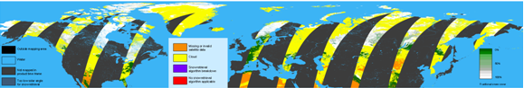
One day of snow mapping based on Envisat AATSR (6-7 April 2003).
Latest project news
|
Phase 1 of the GlobSnow project (2008-2009) focussed on the pan-European area for the development of a Snow Extent product based on ERS-2 ATSR-2 and Envisat AATSR. Work was started in February 2010 for expansion of the coverage to the seasonally snow-covered part of the Northern Hemisphere. A preliminary product was presented in the GlobSnow progress meeting 14 April 2010. A more mature product is planned to be developed by 31 May 2010. See example of a preliminary hemispherical product on the Summary page. Updated date: Thursday, November 15, 2012 - 20:38 |
Contact information

Project period
Financing
European Space Agency