Oceanides
Oceanides
OCEANIDES: Harmonised monitoring, reporting, and assessment of illegal marine oil discharges.
The OCEANIDES project aims to identify and assemble the knowledge required to establish a more harmonised and effective monitoring of European waters of illicit marine oil pollution.
OCEANIDES will address a number of uncertainties concerned with monitoring European seas for illegal oil discharges including lack of agreed consistency of correlating shapes found on satellite imagery with illegal oil slicks, lack of systematic efforts to ground-truth reported oil slicks from space-borne remote sensing, lack of harmonised, systematic reporting mechanism that allows the problem of one sea to be compared with another or lessons learnt in one to be applied more generally, lack of knowledge on the combined space-/air- borne sampling effort required to establish oil spill statistics on a European scale, and lack of quantitative estimates of the environmental impact of illegal oil pollution.
OCEANIDES will specifically use current and traditional satellite/airborne oil pollution surveillance services and infrastructure in order to understand, address and identify the technological, scientific, and legislative requirements for establishing a Pan-European harmonised, standardised, oil pollution monitoring and information reporting capability. It will also apply a state-of-the-art oil spill trajectory/fate and environmental impact assessments model to develop a methodology to assess the fraction of illegal oil spills that are most likely to reach environmentally sensitive areas and the scale of their environmental impact.
OVERALL OBJECTIVE
The overall aim of OCEANIDES will be achieved through the following specific objectives:
- comparing the accuracy and efficiency of different methods - both automatic and manual - for oil-spill recognition in SAR images of satellite and aircraft sensor systems;
- developing a harmonised Pan European reporting system for oil-spills;
- analysing historic archives of images to determine the severity of the problem and understanding how many images or aircraft flights would be needed to establish statistically robust information on oil pollution;
- developing and applying a methodology for determining the fraction of illegal oil spills that are likely to reach environmentally sensitive coastlines and biological resources.
- deriving reliable, seasonal, oil spill indicators and statistics for the Baltic and North Seas;
- evaluating the potential support of satellite oil spill recognition to optimise the airborne surveillance and combating activities and of the probability that slicks detected on images are in fact 'real' oil slicks.
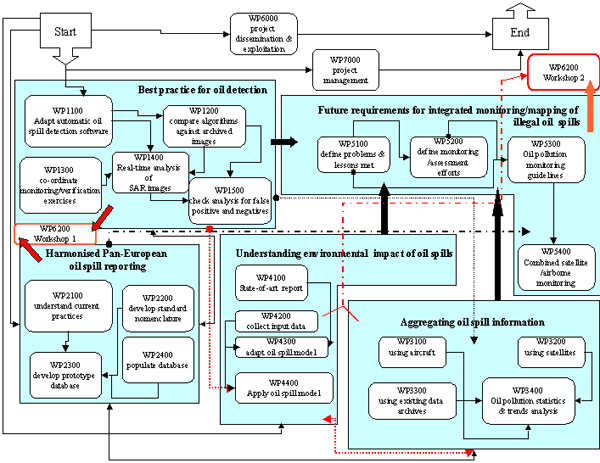
Workplan

Contact information

Project period
Financing
The European Commission