ENVISYS
ENVISYS
The Mediterranean is an area with extensive human activity. It represents important food resources and is at the same time used for cheap waste disposal. Lately, the environmental consciousness in the area has grown largely. Knowing that nature takes 90 years to exchange the entire water body, the ocean can be considered as an almost closed system.
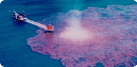
We have only recently become aware of the huge amounts of oil being discharged in the Mediterranean and in other ocean areas. More than 600 000 tonnes of oil are discharged annually. This corresponds to ten times the Exxon Valdez accident. Only a limited amount of the oil spilled annually comes from large accidents like the Exxon Valdez or the Sea Empress accidents. The main amount of oil comes from intentional spills from ships washing their oil tanks after delivering their cargo, often at night.
Radar satellites can detect these spills. The oil dampens the small capillary waves on the ocean surface and changes the radar signature accordingly. NR has been working with automatic methods for oil spill detection in radar images for seven years. The activity in the Mediterranean was organised through the ENVISYS project, which was a European Union project under the Telematics Programme. Industry companies and universities from Norway, Spain and Greece participated in the project, which was managed by NR. The project has developed an extensive software toolbox for detection, verification, assessment of the potential damages, and clean-up management. The satellite images are analysed automatically - untouched by hands - to the point when a possible oil spill alarm occurs. The operator will then use the system to verify that the alarm represents a true oil spill. The verification can also be done using an aircraft. The next step is to assess the potential damages. Does the spill represent a threat to fishery zones or recreational areas? If the situation is serious, a clean-up operation, which can be managed from the system, is started.
WHAT IS ENVISYS
- ENVISYS is a CEC R&D project within the Telematics Applications Programme's sector for environment.
- ENVISYS' purpose was to develop a demonstrator prototype for the detection of marine oil spill in radar satellite images.
- ENVISYS demonstrator software was the first system in the world to detect oil spill completely automatically.
- ENVISYS provides efficient tools for managing oil spill accidents.
- ENVISYS was demonstrated in the Mediterranean coastal regions in Spain and Greece.
- ENVISYS, intended to be operational in 2000, will protect the Mediterranean environment against intentional oil spills, which today amount to an equivalent of about 10 Exxon Valdez accidents.
- ENVISYS may be extended to other emergency situations (floods, forest fires, volcanic eruptions, ...) to provide monitoring of the environment, early detection of emergency situations, warning to authorities and decision support during the management of the accident.
- ENVISYS is based upon the integration of existing remote sensing, communication and software intensive technologies, as well as existing public infrastructure
- ENVISYS was developed by a team of Greek, Norwegian and Spanish companies and institutes.
ENVISYS OBJECTIVES
- To integrate existing remote sensing, communication and software intensive technologies, as well as existing public infrastructure into a fully operational system for sea monitoring, detection of oil spills due to human activities, warning to responsible public authorities, and decision support to the said authorities during clean up operations. To detect a very high percentage of slicks created during demonstration time, constrained only by satellite coverage of the area in question (in terms of time). Achievement of these results with current satellite coverage, implies the systems viability as a very powerful tool for public agencies responsible for such disasters, on a day by day basis, as daily coverage from satellites is anticipated in the imminent future.
- To investigate the cost effectiveness of similar techniques in other disaster areas, most notably forest fires and floods.
- To demonstrate the applicability of concepts and technology to the potential user organisations as well the cost effectiveness of chosen solutions at two distinct sites.
Contact information

Project period
Financing
The European Commission